Beulah Crossroads
Jan
Many locals call the centre of Rhiwbina village Beulah Crossroads, but you don’t need to go back very far, to see a very different village.
If you look at the old Ordnance Survey map of 1880, you’d be hard pressed to find Rhiwbina. In fact, back then it had a totally different name, and there was no village.
The next OS map, dated 1900, is little different. It’s only when you look at the OS map for 1920 that you’d see a recognisable Rhiwbina village.
The earliest photographs only date from c1900, so there’s no help there.
The best source for early information is the old Parish Tithe Map. This is dated 1840, and we’re really fortunate that this map still exists.
The Tithe Map coincides with the first meaningful census, and between them, you get a pretty good idea of how many (actually how few) folk were living in the area. There were lots of farms with individual fields, a few cottages, some meandering tracks, and an old stream. And there were just a few grander houses.
At the start of this new year, I thought it might be fun to look at this tiny corner of the parish and to discover some of the things that have been lost in time.
The Tithe Map lists all of the landowners (nearly all absentee landlords with huge estates), it lists the tenants of the various farms and cottages, and wonderfully the names of so many of the fields. In addition, the census, lists everyone living in each place (husbands, wives, children and even visitors); it is possible to see how the two link up.
I’ve attached a sketch map, based on both the early OS map and the Tithe Map, showing how things were in 1875 (nearly 150 years ago).
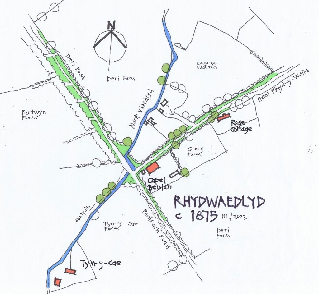
There are no crossroads, just a rural track running from the south, named after a cottage nearer Birchgrove called Pantbach (this was mentioned as early as 1733).
There’s a track running east towards the old parish boundary. This would later become Beulah Road, but back then it was called Heol-Rhyd-y-Walla. Remember until quite late into the 19th century, nearly the whole of the parish was Welsh speaking.
And there was a narrow farm track running northwards, towards Deri Farm. Nothing to the west, just fields.
No Rhiwbina back then. The area was named Rhydwaedlyd after the stream (Nant Waedlyd, the bloody brook!). Rhydwaedlyd meaning the ford on the stream. In all probability, there was an ancient fording-place here, where people and animals could safely cross. There were even earlier names, Rhyd-y-Walla and various other derivatives.
Anyway, back to the sketch map. By 1840 and the Tithe Map, the ancient ford had gone and been replaced by a simple humpback bridge with the stream running diagonally, but by 1875 and this map, the stream had been locally diverted and a flatter bridge provided.
There were three farms which converged at ‘the crossroads’, the nearest was Ty’n-y-Cae to the southwest, Pentwyn Uchaf to the northwest, and many of the fields to the east belonged to the Deri Farm. The fields shown on the southeast corner were an isolated pocket of Graig Farm (incredibly, the Graig farmhouse still stands today, visible from the motorway as you leave the junction at Coryton towards Newport).
There were at least 6-10 more farms in the immediate area, but perhaps we could look at them another time.
On this sketch map, there’s no railway, no Pen-y-Dre, and Heol-y-Deri was the narrow track sometimes called Deri Road.
There were only a handful of little cottages, and according to the Tithe Map, there was a blacksmiths forge on the southeast corner, with John Jarvis and Evan Evans running it.
William Howells was living in a tiny cottage adjacent.
In 1850, some local Christian Independents (they used to be called dissenters) from Watford in Caerphilly, leased William’s cottage and a corner of his field, to use as a chapel. Over the years, the little cottage became too small for the growing congregation, and by the time of this map, the cottage had gone and a small chapel had been built on the plot. They called it Beulah. It wasn’t until 1891 that the new Beulah Chapel that we see today was built on the opposite corner. The old chapel was then used as a schoolroom.
Edgar Chappell in his definitive book, lists a few of the field names locally. Cae’r Efail (the smithy field), Cae’r Bont Garreg (the stone bridge field) and Erw Pont Rhydwalla (Rhydwalla Bridge Enclosure). They’re so evocative.
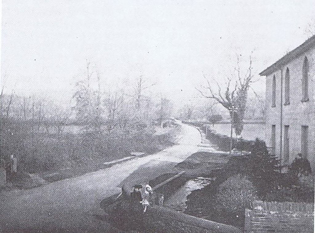
I’ve also included an old photograph; it’s hardly recognisable. It was probably taken c1903 with the newly constructed Beulah Chapel on the right-hand edge, and looking north. The stream is there, the improved bridge and nothing else. If the photograph had a better resolution, the first building you’d see would be Deri Farm!
So, what else was in the area back then, and their stories forgotten?
Castell Morgraig (on the top of Thornhill) and the Twmpath
Deri (the farm and the old tree)
Pwll-y-Winci and Greenhill
The farms of Ty’n-y-Parc, Pantmawr, and the ‘lost’ farm of Ffynnon-Wen
And of course, Deri Mill, and the Butchers Arms
Now Beulah Corner; but so much ‘lost’ history. Or perhaps just forgotten, waiting to be discovered
By Nigel Lewis
Member of AWEN@thelibrary (awen.cymru@gmail.com)