Deri Mill
By Nigel Lewis
In the last issue of Rhiwbina Living, we looked at Beulah Corner and what a difference 180-odd years had made since the time of the parish Tithe Map.
If you remember, I’d produced a map showing how rural the area was c.1875. It showed a meandering and timeless stream and the junction of a couple of rural tracks (hardly roads as we might know them). On the Tithe Map a few years earlier, the ancient ford (called Rhydwaedlyd) had been replaced by a simple humpback bridge leading north to the Deri and then by 1875, a ‘new’ shallower bridge had been constructed, with the stream diverted.
There were a few scattered cottages and one or two larger houses. The first iteration of Beulah Chapel was there, and of course there were the ancient farmhouses, but they were spread over the area.
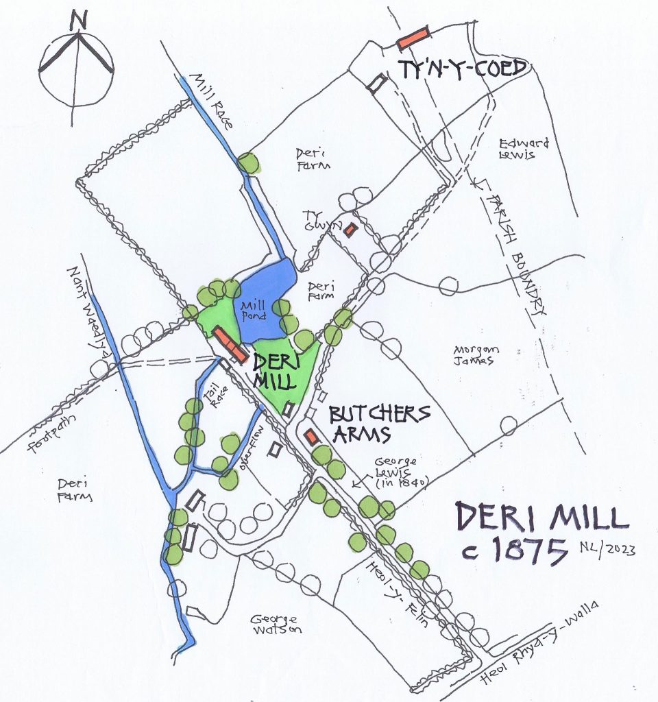
I’ve produced another map, also dated c.1875, just north-east of Beulah Corner, showing an old mill. There’s a tree-lined track off Rhyd-y-Walla (later renamed Beulah Road) leading to a mill. This track is now Heol-y-Felin.

Just like Beulah Corner, the whole area was incredibly rural, with lots of fields. There were a few cottages and then a grander house called Ty’n-y-Coed. The parish boundary with Llanishen ran haphazardly across the area. In fact, it looks as though it ran right through Ty’n-y-Coed; so apart from perhaps a living room and a bedroom, most of the house would have been in Llanishen parish! Its fields certainly were.
Then there was the mill, a millpond, and a pub.
The stream, Nantwaedlyd meandered as it always did, but a millrace had been constructed (quite possibly as far back as the 17th century) diverting some of the stream water into the millpond. By 1840 and the Tithe Map, the mill would have already been very old. At the time, it was called ‘Crofft-y-Felin’ and was owned by Mrs Rachel Lewis of Deri Farm.
The fields of Deri Farm seem almost to wrap the mill, with a few more fields to the south.
The mill, Crofft-y-Felin, was the largest building around (probably bigger than Ty’n-y-Coed), with the large millpond adjacent. Passing through the mill, water from the millpond was discharged via a ‘tailrace’ back into Nantwaedlyd, just about where All Saints Church is today. There was also an overflow, to prevent the millpond from overtopping.
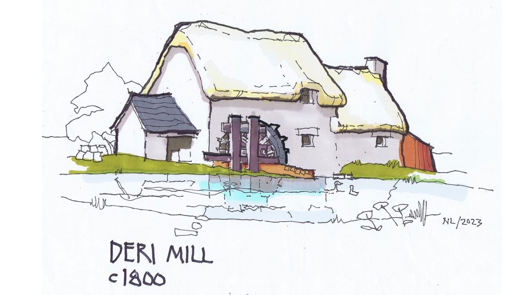
So, what did the mill look like? We’ll never know for certain, but there is help from John Constable’s well-known painting ‘The Haywain’. Painted in 1821, Flatford Mill and Willie Lott’s cottage might well be contemporary with the Rhiwbina mill.
My sketch shows what Crofft-y-Felin/Deri Mill might have looked like back then. Looking from the east over the millpond, was an undershot waterwheel (where the water passed under the wheel) into the old mill building. Almost certainly built from local stone with thick walls, the mill possibly had a thatched roof and all sorts of outbuildings, constructed and altered over many years.
There was another local mill at the time, Felin-Fach (Little Mill) in Whitchurch village. This mill took advantage of the sloping ground there and had an overshot waterwheel. Water passed over the top of this wheel with greater power. As a result, Felin Fach was probably more efficient than the older Deri Mill.
In the 1861 census (just 14 years before this map and sketch), there were five families shown living at Crofft-y-Felin/Deri Mill. They may not all have been living in the mill itself, some may have been in the adjacent cottages:
Morgan Salathiel, age 46, was the miller, living with his wife and two adult children, who probably helped in the mill. William Howell, age 44, was a mason, living with his wife and two young children. Thomas, age 73, was an agricultural worker with his wife and two adult children (the son was blind). William Llewellyn (spelt differently from Thomas Llewelin), was 23, with his young wife. And then there was Evan Evans, age 39, who was a cooper, living with his wife and three young children.
Counting them all, there were 19 people living in and around the mill!
In addition, there were another five families living in other cottages nearby, so around Crofft-y-Felin, it was quite a community. Everyone would have known everyone else!
And then there was the pub:
It wasn’t there in 1840, but the narrow strip of land that would eventually become the Butcher’s Arms was owned by George Lewis. Was he related to Rachel at Deri Farm? Interestingly, George wasn’t there for the next census, but a George Lewis had become the landlord of the Three Elms pub on Whitchurch Common. Might he be the same man?
By 1861, Isaac Richards, age 39, who was a butcher, was living in an un-named local public house. Isaac had a wife and young daughter living with him, and also Jane Salathiel, age 17, from Deri Mill. I wonder whether she was working at the pub.
By the time of the next census, and this map, the Butcher’s Arms had been named and established.
The mill, millpond, and cottages are all gone now, replaced by modern houses. There’s only a plaque on a garden wall nearby, acknowledging the story.
Even the Butcher’s Arms has been rebuilt a few times. But that’s a story for another day!
Member of AWEN@thelibrary (awen.cymru@gmail.com)

